Sarek national park is located in the Swedish part of Lapland to the north of the Arctic Circle. Although (or should I say because?) I had visited the area already last year I returned this year to walk a different route and spend again two weeks in one of the most remote areas of Europe. With this article I want to give you some background information on my hike, my motivation and practical aspects.
Why?
This is a question that many people ask me. Well, there’s actually a lot of reasons why not to go hiking in Sarek:
- Rough weather – among the most rainy areas in Sweden
- No marked hiking trails – often no trails at all
- No accommodations, no re-supply – you have to carry everything yourself.
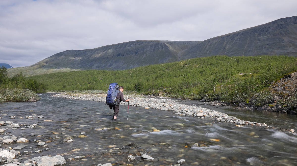
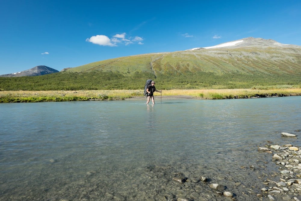
- You may encounter streams that are hard and dangerous to cross.
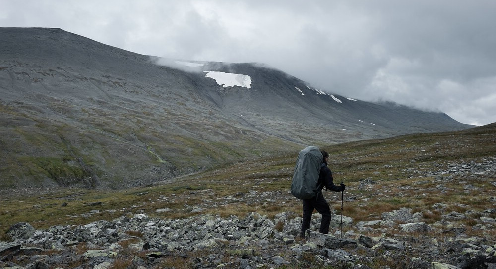
- Rough terrain means strenuous hiking (while carrying a heavy load)
- No mobile phone coverage – reaching the next emergency phone may require days of hiking
If you are not put off by those aspects, are aware of the dangers and have experience in multi-day hikes it is an awesome place to go:
- Almost untouched nature and real wilderness (almost because the area has been used by the local natives – the Sami – for centuries as grazing ground for their reindeer)
- Landscape rich in variety (mountains, rivers, lakes, forests, glaciers)
- Few visitors – you may not encounter other hikers for days
- Countless possibilities for your own custom route with varying degrees of difficulty and many interesting summits
- Ever-changing light – an eldorado for photographers
Last year’s trip left such an impression with me that I decided to return this year. Now that I am reviewing the pictures of my recent hike, I know for sure that I will return again. There is so much left to explore and even the places I know already will look distinct in different light or weather, or seen from a different angle.
Preparations and planning
A longer hike in remote areas such as Sarek requires careful planning and preparation. After the decision about the region you need to get information on how to get there and when. The summers are short in Lapland and if you want to hike and not ski there are only few months left: June, July, August and September. June however is a bit early for the mountains as the snowmelt is still in progress and most rivers will have high water levels making fording difficult. Of the remaining period I opted for the end of August/beginning of September. The advantages are that there are only few or no midges left and the risk of snow is still low. In addition, you can expect lower water levels if it is not too rainy.
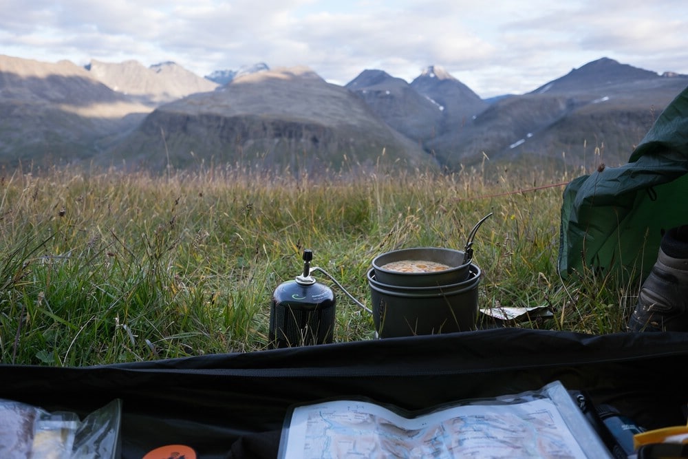
After this initial planning it is time to investigate possible hiking routes. This requires at the least a detailed map. In an area without marked trails, however, a map alone does not suffice because it is not always clear which areas can be traversed and which cannot. Often streams can only be crossed in specific places which is not evident from a map. You can either research this information in the net, contact hikers who have been already there or buy a book. I took the latter option and consulted the very detailed guidebook from Claes Grundsten which is currently available in Swedish and German.
Equipment
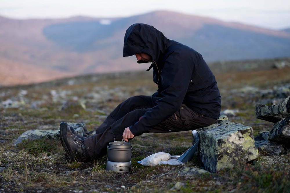
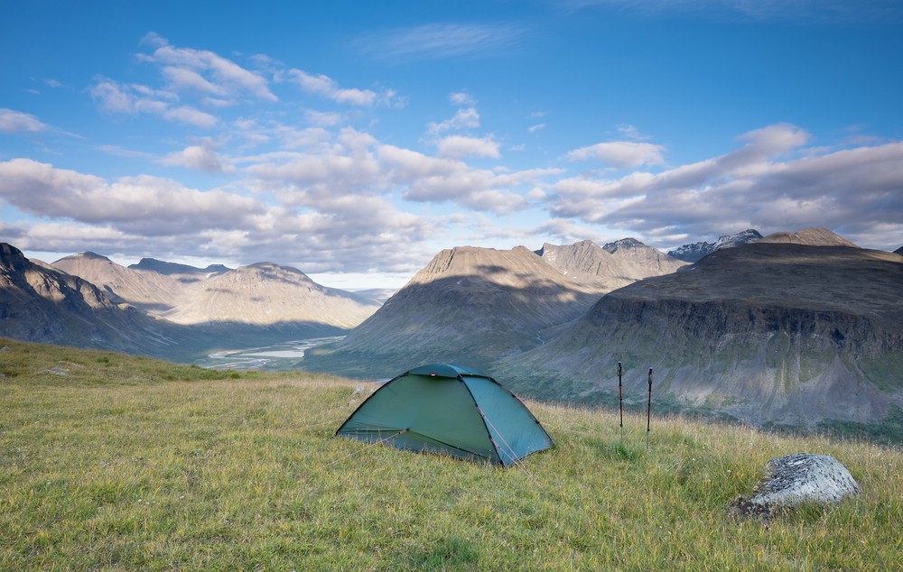
When hiking in Sarek you need to carry everything you need with you. Depending on the time you spend there this leads to a heavy backpack, especially if you also want to bring camera gear. In my case I had an initial backpack weight of about 29 kg of which 12 kg was food only. Your tent should be fit for harsh weather conditions and your sleeping bag be warm enough for temperatures slightly below freezing. The nights might be quite cold, especially if the sky is clear. I often had hoarfrost in the morning. Better take more durable gear than lightweight but weak equipment because your life may depend on it.
Things that are not as obvious as rainclothes, stove and sleeping pad:
- Hiking poles or a hiking staff are a necessity when crossing streams and help when hiking with heavy backpack.
- Light plastic shoes for fording rivers – fording with bare feet is very risky
- Neoprene socks also help when fording rivers as the water is icy cold
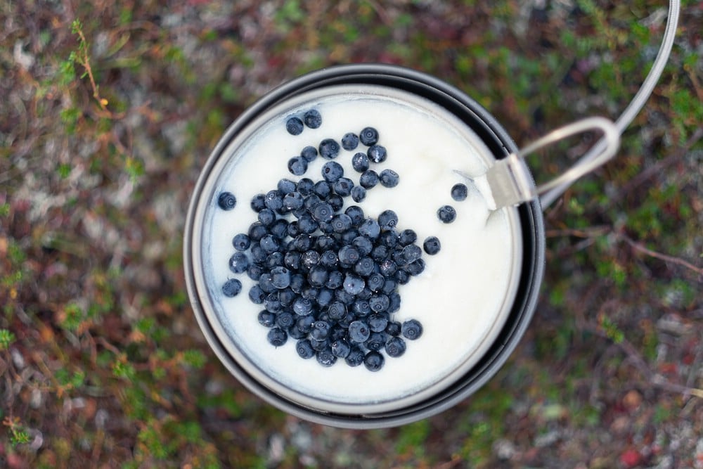
Water is available everywhere; it is drinkable without any treatment and tastes good.
Regarding photographic equipment, everyone has to decide for him/herself depending on the his/her photographic preferences. Usually compromises due to weight are necessary. I opted for a mirrorless system camera with full-frame equivalent lenses ranging from 21mm to 85mm (3 primes). I deliberately did not bring a telephoto lens, although I could have used it occasionally. Instead I packed a tripod and filters (polarizer, solid and graduated neutral density) which have seen a lot of use. Of course you have to bring enough batteries and memory cards to last for the entire trip. One more thing that you should consider – especially if you are hiking alone – is a remote trigger as it permits interesting possibilities of self-portraits (like the ones in this article). As my camera had WiFi, I was able to use my mobile phone for this purpose.
Weather
I have been lucky with the weather during both of my Sarek trips, this year even more so as there was hardly any rain which is quite unusual. Although not every day was sunny, I also had some really awesome days as you can see in the image below.
However, you have to expect a lot of rain and be prepared for it. I have heard reports from hikers that have not seen a single mountain for their entire hike! The weather is also very local and may be different from one valley to the next. When planning your trip should take that into account and allow extra time for days you may have to spend in your tent. Luckily this did not happen to me, so I used the additional time for some detours and shorter stages.
The Route
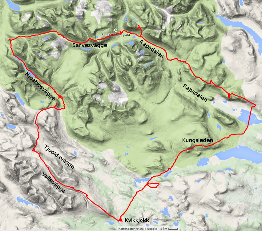
Last year I crossed Sarek national park from north to south. This year I focused on the southern part of the area, in particular I wanted to explore the valleys Njoatsosvágge and Rapadalen that I had not visited last year. As I also knew only a small part of Sarvesvágge I decided to integrate it as well. In comparison to last year’s hike the terrain was more difficult, there was much more brush and undergrowth making hiking strenuous. But I got rewarded for the effort with spectacular views of the scenery. Especially the river deltas in Rapadalen – Rapaselet and Laitaure – were really stunning.
My hike started and ended in Kvikkjokk, overall I covered approximately 200 km (according to GPS data). The mileage varied between days and depended much on the terrain and other aspects such as interesting photo spots. Not the whole trek (in clockwise direction) was inside the boundaries of the national park which is highlighted green in the map below. For the return from the Laitaure lake to the east of Rapadalen I used the well-known hiking trail Kungsleden (including some pathless detour you can see in the GPS route).
Hi,
I’m planning to hike Sarek in August. I was wondering if you had some advices for an 7-8 days itinerary? Thank you
For 7-8 days there are many possibilities, some suggestions are for example:
Ritsem – Ruohtesvágge – Skárjá – Stáloluokta – Padjelantaleden – Ritsem
Ritsem – Ruohtesvágge – Skárjá – Bastavágge – Rinim or Suorva
Ritsem – Ruohtesvágge – Skárjá – Rapadalen – Aktse – via Kungsleden to Sáltoluokta or Kvikkjokk
Suorva – Bierikjávvre – Rapadalen – Aktse – Sáltoluokta
Kvikkjokk – Pårte – Njoatsosvágge – Tarradalen – Kvikkjokk
…
and many more. Some of those might take too long depending on your hiking pace. You should plan your hike in detail, to be sure that you have sufficient time and spare days for when the weather gets nasty or streams become impassable.
A good reference are these online maps. Switch the type of the map to “Fjällkartan”.
He Stefan,
I’m planning this summer to go to Sarek and want to go through the Basstavagge valley coming from Bierikjavvre andgoing to the Suorva damm. After the valley I need to wade through Sijddoadno river to get to Suorva.
I saw your route suggestions, so is that river manageable to do with my 14 year old son? Have you waded through that river?
I hope you can help because I looked all over the internet for Info on this?
Thanks |Heikki
Hello Heikki,
I haven’t yet hiked this route (but I want to do that in the future). In fact, there’s no need to cross Sijddoädno, you can stay to the west of that river and hike northwards to the west of Sjuodji where you can see several small lakes. In the valley of Sijddoädno there seems to be forest/brush according to the map, so I would try to avoid it.
In addition, my guidebook suggests crossing Njábbejåhkå where the letter “N” is on the map (at least when the water level is high).
Nevertheless plan extra days in the case there are problems with rivers/water levels to be able to wait or choose an alternate route.
Enjoy your hike :)!
Stefan
Hello, Stefan, could you please write, how long did it take you to do the trek? Thanks Ursula
Hi Ursula,
I had two weeks of time, but it can be done in less. However, if you want to make some detours or take some time off, it’s always good to have some spare days. Plan for bad weather and impossible river crossings (you need to wait then or change your route) as well.
Stefan
Hi there. Just what I’ve been searching for. I’m planning on starting from akste and pretty much following this route to Kvikkjokk.
Would you have a gpx route I can place into ViewRanger to have a look at it on the map?
Thanks in advance.
My email is martin@vildmark.co.uk
Hi Martin,
I’m sorry to disappoint you. I do not provide GPX files. More about my reasons can be found here.
However, if you have any questions about the area, I’m happy to answer them.
Cheers
Stefan
Hej Stefan!
Could you suggest a route which can be done in 4-5 days with a relatively easier terrain to traverse? We don’t have much experience with hiking but we really want to see those views! Thanks!
Regards
Prithvi
Hej Prithvi,
In my opinion, 4-5 days is too little time to hike in the area. One possibility would be to hike Kungsleden von Saltoluokta to Kvikkjokk and then do a detour to Skierffe which really provides an impressive view. Kungsleden is marked and relatively easy to walk. However, you will really need those 5 days depending on your pace. So plan wisely.
Cheers
Stefan
Hallo,
ein herzliches Danke Schön einmal vorausschauend für die vielen, sehr informativen Einzelheiten zum Sarek.
Auf den ersten Blick fast ein wenig Respekt einflößend, auf den zweiten Blick “Eldorado” (für Fotografen).
Ich habe die einzelnen Artikel mit Aufmerksamkeit gelesen und vorab nur eine “kleine” Frage. Mit welchem der vielen Wanderführer von Claes Grundsten bin ich am besten beraten, wenn ich noch nicht genau eingrenzen kann, in welches Detailgebiet es mich vielleicht mal verschlagen wird.
Vielen lieben Dank . . . . ich bin am Beginn einer (langen) Planungsphase . . .
Klaus Bernhard
Hallo Klaus,
als deutsche Ausgabe gibt es von Claes Grundsten nur ein Buch über den Sarek:
http://claesgrundsten.se/bok/sarek-trekking-in-schweden-2/ (Buchseite des Autors)
Diese findet man bei den üblichen stationären und Online-Händlern. Ich kann jedoch gerade nicht genau einschätzen, was Du mit “Gebiet” genau meinst. Ein Untergebiet im Sarek oder die anderen großen Gebiete im schwedisch-norwegischen Grenzgebiet in Lappland (etwa Padjelanta, Kebnekaise-Gebiet)? Grundsten hat auch Bücher über diese Gebiete veröffentlicht, jedoch bisher nur auf Schwedisch.
Viele Grüße
Stefan
thank you so much for your reports on sarek. i am planning a trip and they have been really valuable for understanding terrain, fords, and vegetation.
i was wondering if you had an idea of what your average km/h hiking pace is? trying to understand how realistic some of my daily routes are. i am putting together a route that is similar to your saltoluoka to kvikkjokk trip, but was trying to see if i could realistically do it in 10 days.
thanks again for these write ups.
First of all thanks for your feedback! It is possible to do the hike in 10 days. I had more time and thus it wasn’t necessary for me to walk long distances every day. There are days when you can cover a lot of ground and sometimes, e.g. in the lower Sarvesvágge or Rapadalen there may be slower progress. I think the distance covered on this route is roughly 150 km. You could do some shortcuts if weather is bad and for example omit the loop via Álggavágge and Sarvesvágge.
Hi! you seems like just the man I need(in a hiking sort of way 😉
So my plan is to WALK the entire Kungsleden. That means I’m going to either wada over shallow parts of the rivers, or walk around them… even if that means I have to for example walk uppstream för more than 40k, then so be it.
At theese 7 waterpasses(Teusajaure, Saltoluokta, Sitojaure, Aktse, Kvikkjokk, Lake Riebnes and before Jäkkvik), most I allready know how to pass. But the passes I have trouble with, and were I’m in need of your sseming expertise is:
1. Is Teusajaure possible to cross anywhere(AGAIN), even if that menas walking for example downstrem for 55k)?
2. Crossing by Sitojaure(Sjiddädno), I was thinking walking down strem about 4k and wada there, is that possible?
3. Kvikkjokk, is it possible to cross anywere upp och downstream?
4. Aktse(Laitaure lake) – Is it possible to wada abouty 8.8km downstream, measured from the cabin?
Thanks for your message! You shouldn’t worry crossing rivers or lakes on Kungsleden. The reason is that there’s boat transfer on the mentioned lakes. I haven’t been to Riebnes yet, but I assume there too. Some years ago, there were also rowing boats placed at the lakes. They have unfortunately been removed recently. Other larger streams usually are bridged.
If you really want to cross the rivers (flowing in or out of the lakes):
1. May be possible with low water levels to the east but you have to walk across the summits to the north of the lake first. It’s beautiful though, have been there (but not crossed the main river).
2. I don’t think so.
3. No.
4. No.
Summarizing: Use the boats :-).
Hi Stefan! Many thanks for your helpful posts! We are planning a trip similar to yours in Sarek, and were wondering the hike through Rapadalen and crossing of Ráhpaädno (Rapa River) near Låddebákte. Was the vegetation in the valley very dense / would it be possible to cross in higher path? Where did you cross the Rapa River?
All the best!
You can cross directly up- or downstream of a small elevated island in the middle of the river. Here the river is forming many channels. The deepest water is directly adjacent to the island.
If water levels are high, a crossing is impossible. In the following I painted red lines where the location is roughly located.
The map is from this site which is good for planning:
https://minkarta.lantmateriet.se/
Hi Stefan, how difficult was the Sarvesvagge part (horizontal part on your track). We were considering walking it in the other direction. As an alternative we have in mind following the rapadalen “trail” further north and then take at Skarja into the Alggavagge. Any suggestions?
Hi Silke, Sarvesvagge is not more difficult than Rapadalen. You will have some brush mostly in the lower part of the valley. The upper valley is easy to walk. Both routes that you suggest are beautiful. The river crossing in my post above can be difficult. Last September I actually did the crossing again and it was very dangerous. In my previous comment I said that the water next to the island is the deepest. This didn’t turn out to be true during my latest crossing. The channel closest to Låddebákte turned out the most difficult, fast-flowing and deep. It might be that the channels change over time due to sediment moved by the river.
My advice: Coming from Aktse check water level and current, and, if it turns out to be too difficult, continue along Rapadalen. As I said, both options are beautiful.
Hello Stefan,
Well done on your website! It’s great to hear about other people’s experiences.
My partner and I would like to explore Sarek next July. We haven’t finalised our itinerary yet, as we’re looking for a nice route through the park and the opportunity to climb one or two peaks. Our instinctive choice is the following route: Ritsem – Ruohtesvágge – Skárjá – Rapadalen – Aktse – Kvikkjokk. Does this route offer a good overview of the region’s beauty, or are there any major points of interest missing?
I am open to suggestions for summits that can be hiked (without glacier equipment).
Many thanks.
PS: we are well equipped, but we are still unsure about which shoes to take: nylon sandals, trail shoes, high-top leather shoes, rain boots…
Your planned route is a good one. It is one of the “standard” options. You’re doing nothing wrong with it and will see many beautiful places along this hike!
There are lots of possible summits along the way and I think it depends on your expectation regarding the peaks. I haven’t done most of them just read about possible ascents, so please take it with a grain of salt. A good reference is the book “På fjälltur Sarek” by Claes Grundsten (available in Swedish and German only, however, see claesgrundsten.se/bok). There most of the below ascents and many more are described.
Some summits may be easier while others can be challenging. Above a certain altitude you can expect to have lose rocks and boulders all the way.
Some summits:
* Gisuris (should be quite easy from the west)
* Niják (via Nijákvágge, southeast ridge; I think it’s steep & exposed)
* other peaks flanking Ruothesvágge, check for the ridges that are less steep
* the small hill Ruohtesvárásj is not a real peak but offers a nice view and is quickly climbed
* the Sarek massif (2nd highest peak in Sweden) is probably too challenging and requires climbing on very exposed ridges
* Skárjátjåhkkå (east ridge)
* Låddebákte – highly recommended; always wanted to go but never “right” conditions; climb up from Snávvávágge
* Stuor Skoarkki via Jilávágge
* Skierffe – stunning view of Laitaure delta, highly recommended, but you won’t be alone 😉
* Nammásj down in the valley if you take trail on the valley floor of Rapadalen
* Tjahkelij – more like a plateau, but ascent is only possible through a crevasse on its south-east end coming from Kungsleden; you will be alone here
If you don’t have a lot of extra time for summits I would recommend Låddebákte and Skierffe.
Regarding shoes: I would recommend taking real leather hiking boots, but I am an old-school guy. Trail shoes may be possible if you’re really used to them on rough terrain – the ultralight people nowadays use them everywhere. If you want to climb more challenging peaks, I would strongly advise against them. If you hurt your feet seriously you need an emergency evacuation.
Sandals are out of the question, except for crossing rivers. If you don’t want to get your shoes wet bring some light sandals or plastic shoes like crocs in addition to your hiking shoes. Never cross with bare feet.
Remember, there’s no cell signal, so use a satellite messenger, if in doubt.